"This is a discussion forum about the community buy-out of The Bell. Post away, but if you're being offensive, insulting or over-personal, if your language is excessive, or if we deem you're advertising something not connected with the project, your post will be removed by the moderators."

  • Page:
  • 1

TOPIC:

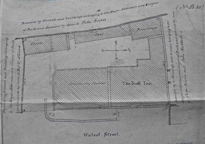
Old map. 03 Mar 2019 13:22 #1

  • bushy
  • bushy's Avatar Topic Author
  • Offline
  • Elite Member
  • Elite Member
  • Posts: 184
  • Thank you received: 115


For anyone who hasn't seen it, here is an old map of the pub. I think it is early 19th century.

Note the low wall running from the left of the front door to just around the corner of the yard. There is still an iron gate hinge on the front wall. This wall was to prevent people alighting from coaches from being splashed by mud from other passing coaches. It was three feet high and - I believe - slabs of it were used to form the two side cheeks of the wall at the bottom of the steps to the garden.

Lots of stables and a brewhouse where the back toilets are now!
Attachments:
The following user(s) said Thank You: jamesmatthews, Spine, geojay

Please Log in or Create an account to join the conversation.

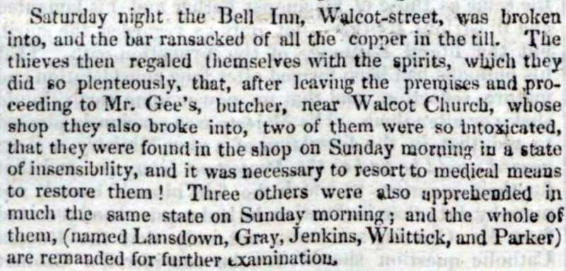
Old map. 05 Mar 2019 10:57 #2

  • bushy
  • bushy's Avatar Topic Author
  • Offline
  • Elite Member
  • Elite Member
  • Posts: 184
  • Thank you received: 115


1827. Some things don't change.
Attachments:

Please Log in or Create an account to join the conversation.

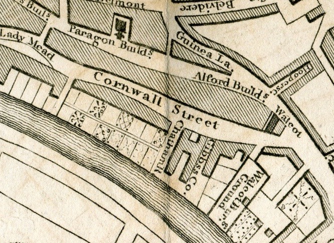
Old map. 05 Mar 2019 16:54 #3

  • Alan
  • Alan's Avatar
  • Offline
  • Junior Member
  • Junior Member
  • Posts: 39
  • Thank you received: 29
sounds like a good night out
The following user(s) said Thank You: bushy

Please Log in or Create an account to join the conversation.

Old map. 09 Mar 2019 12:29 #4

  • bushy
  • bushy's Avatar Topic Author
  • Offline
  • Elite Member
  • Elite Member
  • Posts: 184
  • Thank you received: 115


Stop me if I'm boring you. The stretch of Walcot Street by The Bell used to be called Cornwall. The Bell's address used to be 1 Cornwall Street. Walcot was the parish. The buildings opposite are still called Cornwell, with an e I think.
Attachments:
The following user(s) said Thank You: jamesmatthews, John Revell

Please Log in or Create an account to join the conversation.

Last edit: by bushy.

Old map. 20 Apr 2019 14:34 #5

  • bushy
  • bushy's Avatar Topic Author
  • Offline
  • Elite Member
  • Elite Member
  • Posts: 184
  • Thank you received: 115

The top map shows stables and outbuildings against the retaining wall of the garden, but these are not the same as the ashlar-built one that is there now as the Back Bar. What did they do with all the freestone when they demolished them to rebuild in the 19th century? I reckon they built the huge wall to the left of the garden gate which forms the side wall of what was the Garden Shop.

There is a little bit of evidence to support this. In the centre of this photo you can see an iron ring set into a stone to tether a horse to (now used to tether a plant). The thing is that the ring is set about 8 or 9 feet up from the path, and the path itself has been raised in height over the years. Unless horses were much bigger in those days...
Attachments:
The following user(s) said Thank You: jamesmatthews, John Revell

Please Log in or Create an account to join the conversation.

Last edit: by bushy.
  • Page:
  • 1
Time to create page: 0.412 seconds
No Internet Connection